


Floods: How can you avoid them?
Most of us have seen videos and photos of the massive destruction caused by flooding in North Carolina, Florida, Valencia, Spain, and other regions.
Why are these record floods happening, what causes them, and how can we avoid flooding of our own homes?
How do floods occur?
When rain falls, water drains from the highest points to the lowest points in the landscape into an area we call a watershed.

A watershed can cover a very large territory. For instance, rain from 31 states drains into streams, small rivers and eventually, into the Mississippi River valley. Each of these smaller rivers is their own watershed and can have their own flooding issues, but eventually, it all drains into the Mississippi and Gulf of Mexico.
https://commons.wikimedia.org/w/index.php?curid=9412752
During a normal rainstorm, ecosystems can absorb the excess rainfall through roots of plants, lakes, ponds and depressions in the landscape (like ditches) and no flooding occurs.
But when there is heavy rain, the water comes too fast to be absorbed and a huge amount of it can end up in the major tributaries and rivers, causing flooding in the valleys, which are often relatively flat. The lowest parts of the valleys can flood regularly and are called floodplains. Depending on various factors, these can flood every year, every few years, or rarely. Valleys, including parts or all of the floodplain, are often settled and farmed because of easy access, ease of development, fertile soils and other conveniences.The result is that a portion of many towns, cities and farms are located in areas most vulnerable to flooding.
We have had record breaking temperatures worldwide over the last couple of years, including in the Gulf and Atlantic. Warm temperatures cause more water to evaporate which means there is more of it in the atmosphere, leading to more rainfall potential. Warmer ocean temperatures can cause larger or more powerful hurricanes. Thus, we’ve been experiencing bigger and more destructive rain events, including hurricanes, worldwide. This is a simple explanation of a multi-faceted process which deserves its own article. Suffice it to say that a warmer climate is causing more dramatic flooding events in many parts of the world, based on, in part, the simple physics of heat and evaporation.
What increases flood risk?
The simple answer is: Where you are in the watershed and what the landscape is like higher than you largely determines flood risk. If you’re in a floodplain your chances for flooding are excellent. We believe no buildings should be built in floodplains but some developers don’t agree with that. We advise clients to avoid buying buildings in floodplains. FEMA (Federal Emergency Management Agency) offers flood maps that have some use. These are used by insurance companies and others to determine whether a homeowner needs flood insurance. We feel they are inadequate to express current flood risks and that people should expect risks to extend beyond current FEMA maps in many locations. FEMA is in the process of updating its maps to better reflect current risks. You can input your address into the interactive map portal here: https://msc.fema.gov/portal/home

There are a number of ways that flood risk can be reduced in any watershed, including on your own property. This illustration includes a few of these ways.
Wetlands can absorb and hold tremendous amounts of water and allow it to soak into the ground instead of staying on the surface. Removal of wetlands means that water is going to continue to flow above ground to the lowest point, the floodplain.
Forests also slow and absorb water into their root system and eventually into groundwater storage, or evaporate back into the atmosphere through their leaves. Some trees, such as cypress trees, have more capacity to absorb water than others.
Native perennial meadows can absorb a significant amount of water. They have deep root systems (up to 18 feet deep!) that act like sponges that can absorb and store hundreds of thousands of gallons of water per acre in a rainstorm.
Lakes, ponds and dams are other ways to hold and store water in a watershed.
Regenerative agriculture builds fluffy, aerated soil that can absorb significant amounts of water as well. Where water can be absorbed, underground aquifers can hold water too. How fast this occurs depends on a number of factors like how deep the aquifer is and how porous the soil and bedrock are.
Landscapes that don’t do a good job of slowing or stopping water from rushing into the floodplains are hillsides devoid of trees, chemical agriculture which compacts soils, annual crops like corn with shallow roots that don’t hold a lot of water, cities and towns full of cement, and filled in or paved over wetlands.
So, while we tend to build and farm in the most vulnerable places for flooding, we’re also creating the conditions for more severe flooding with our destruction of forests, wetlands, healthy, absorbent soils, and other natural elements that can absorb water and slow it down. Even if we maintain many water catchment methods, flooding can still occur. This happened in West NC with Helene, in one of the biggest areas of intact forests left in the US, because of the sheer amount of water that fell in a short time period. It would have been even worse with more clear cutting and other development damage.
Recent events
While the devastation in the Appalachian mountains deserves its own in-depth coverage, I’m going to share a lesser known event in west central Florida where we live. It’s a story worth telling. This has barely been covered by the news yet has impacted a number of homes and businesses and continues to do so.
Our local Withlacoochee River is still flooding at record heights in some places weeks after hurricane Milton hit our coast on October 9 and dumped well over a foot of rain in our region. There has been little or no rain since, so why was the river still rising and flooding almost a month later in some places?

This river twists its way through several counties in West Central Florida, sometimes called the Nature Coast because of the copious springs, swamps, lakes and rivers. It sources from the Green Swamp, a huge area of central Florida that is the source for most of the major rivers in Florida.
The swamp is able to absorb a tremendous amount of water and thus reduce flooding, but Milton dumped 18” in some places in a period of hours. This was shortly after Helene had already saturated the area with rain and at the end of a generous rainy season so absorption capacity was already low.
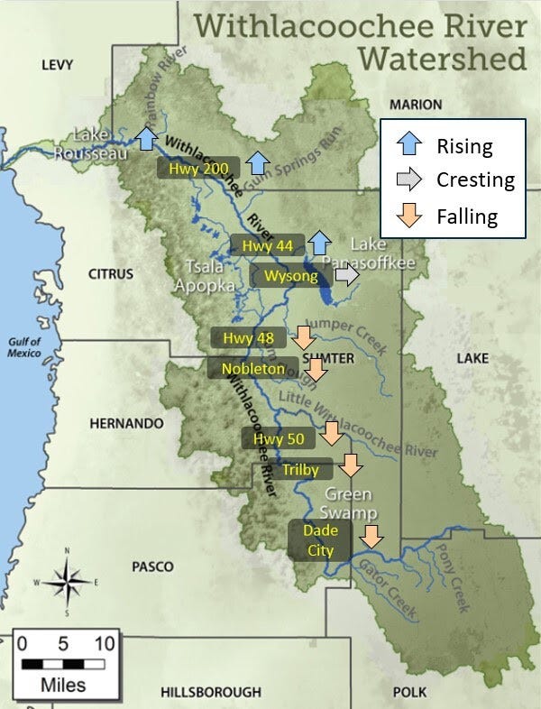
October 28, 2024. Flooding is still rising over about ¼ of this watershed (shown in dark green).
Flooding has exceeded hurricane Irma’s record flood levels as well as many earlier hurricane levels. The extent of this after-hurricane damage has not been communicated very well by news outlets. Very localized TV and newspapers are discussing it to some degree. This is not a unique situation. There is flooding happening currently in various parts of the country that also isn’t in the news. It just isn’t dramatic enough but people are affected nonetheless. Which is why I’m covering this particular topic. How do you avoid being affected?

This watershed is engineered and controlled with many pools, gates, channels, sloughs, and other water catchments built the length of the river to control flooding. Engineers move the water from place to place to minimize flooding and generally do a very good job of it. But beyond a point, we do not have the capacity to control record rapid rainfall that occurs over a large area.
Why does it take so long for this river to crest and why isn’t it draining?
The Withlachochee slowly moves 141 miles down a channel that barely slopes. In some places, the slope may be as small as 1 inch per mile. Movement might be barely perceptible and as flood water recedes, it can slow the movement even further. The aquifers are full so there is no drainage there. And the river is tidal so the ocean pushes the water upstream twice per day. There is another factor that may be contributing, though we have no engineering report to prove it. New developments are exploding in our region. Massive and sprawling recent developments near the headwaters of this river in Pasco, Lake and Polk counties reduce tree cover, fill in swampland, increase impermeable surfaces like cement and compact soils. This can greatly increase run off. We are seeing thousands of homes being approved to be built in our county and the rest of Florida - how will this impact our flood zones?
How can you prevent flooding?
Understand as much as you can about your watershed and flood patterns within it. This is a complex topic that hydrologists specialize in but simply knowing the scope of your watershed and where you are within it can be helpful and instructive. It’s also really fascinating to learn about the life giving source of water in your area.
If a lot of tree clearing or development is occurring upstream from you, you can predict that your zone may become more susceptible to flooding. In permaculture, we like to work in bioregional groups that encompass watersheds. By working together and sharing knowledge, we can make and influence better design decisions for ourselves, our families, and our communities.
Know what your flood zone is. FEMA flood maps allow you to find your address quickly and easily. https://msc.fema.gov/portal/home Remember that these are not fully accurate at this time as the 100 year flood line will increase in many areas of the country, and the current maps are less severe, and potentially much less severe than they will be in any serious storm event. A more robust map can be found at First Street, though a detailed report is not free. https://firststreet.org/
If you live in a flood zone, strongly consider moving to higher ground. The odds are pretty good that your home will flood, sooner or later. If you want to stay there, consider flood resistant solutions like stilts or other flood proofing. Realize that storm surge or major altitude change watershed can create powerful, fast moving flooding that is hard to protect from. You risk compromising your investment if you’re in a flood zone. (See Sources below.)
If you’re considering a place to live, be sure to check the flood zone levels and your watershed.
There is much more to be known on this topic, especially if you’re in the mountains or very water saturated areas.

What happened in Valencia, Spain is not a unique situation. There are photos similar to this in multiple cities in the US and around the world. Using permaculture whole systems design principles in all of our human settlements can prevent this from continuing to happen. The good news is that these principles can be used by anybody - in any occupation, any project, to ensure the outcome is more resilient, ecologically friendly, and safer for us - resulting in an overall better quality of life. Permaculture design includes a very powerful set of design and decision making tools that are deeply needed in the world at this time. This is a big topic that this article can only touch upon.
Sign-up for our Online and In-person Permaculture Design courses which cover strategies for flood prevention in much greater detail. We’ve expanded the “climate resilient design” section of the course which includes sections on dealing with fire, flood, wind and drought. Become part of the solution by continuing to learn more about this topic and help others to understand it better. Association for Regenerative Culture (ARC) and the Permaculture Institute of North America (PINA) have partnered to create a resource base and working group to raise awareness and forward solutions at scale.
Join Permaculture Institute of North America. Introductory membership in Permaculture Institute of North America is only $20 per year, and you are supporting worthy projects that are making a difference, including continuing education. You can also donate any amount to PINA to help us continue this work. https://pina.in
Volunteer. If you’re interested in volunteering for this project, especially if you have related skill sets, contact us for more information.
Want to become a Permaculture success? Checkout our online and in person permaculture courses under the direction of Koreen Brennan!
Grow Permaculture Curriculum and Courses:
Are you ready to take your next step in Permaculture? If so, we’ve got you covered from novice to all-star. Our our courses are under the direct supervision of Koreen Brennan, educator, diplomate, and PINA board member.
Online Permaculture Design Course
The internationally recognized Grow Permaculture Online Permaculture Design Coursecomes with hands-on practical and mentoring. Now more than ever, people have attention on creating more choices and resilience in their lives. We want healthy food, a clean environment, happiness and security for us, our children, and future generations. This course offers practical steps to achieving these things in your own life, regardless of your circumstances. You can get started right away! Sign up now!
In-Person Permaculture Design Course
This is Grow Permaculture’s internationally recognized In-Person Permaculture Design Course. This course will be held in St Petersburg, FL, and at our farm in Brooksville, giving people an opportunity to see permaculture in action on both the farm while also studying in an urban environment. Space is limited sign up today!
Check out our full lineup of Grow Permaculture Courses!
Social Media Posts
Thanks for reading PermaLife! Subscribe for free to receive new posts and support our work.
Sources
* Free article on effects of real estate values in flood prone areas
FEMA flood maps
https://msc.fema.gov/portal/home
First Street flood/disaster maps - a more robust version than FEMA (full report costs $)
Withlacoochee Watershed Initiative (your local watershed likely has something like this)
https://www.swfwmd.state.fl.us/projects/withlacoochee-river-watershed-initiative
Withlacoochee flooding weeks after hurricane Milton
https://www.foxweather.com/weather-news/river-flooding-hurricane-milton-hillsborough-county-st-johns
Nov 9, 2024 Weather.com warning (now reduced to moderate flooding stage):
The Flood Warning continues for the following rivers in Florida...
Withlacoochee At US 41 Dunnellon affecting Levy and Citrus Counties.
Withlacoochee River At Croom affecting Pasco and Sumter Counties.
Withlacoochee At SR 200 Holder affecting Citrus County.
Withlacoochee At US 301 Trilby affecting Hernando and Pasco Counties.
Water levels will remain elevated through the weekend along the Withlacoochee River.
For the Withlacoochee...including US 301 Trilby, Croom, SR 200 Holder, US 41 Dunnellon...Moderate flooding is forecast.
This is an awesome explanation that would benefit many who live in this region. There is so much misinformed discussion out in the public realm that doesn't recognize the need for change. Thank you for sharing this. I am working schedule now to attend one of your PDC in 2025.
I am a semi-retired Florida architect who feels that my profession has neglected the basics of site design in the mad dash to design/build at any expense. Permaculture holds the key to do a better job and provide value added to our projects. Never stop LEARNING!